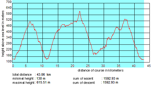
Eberbach 3-Mountain Marathon: Detailed location plan

Difficulties ...
    ... (common):
  • quite some medium ascents greater than 10% for parts of length longer than 1 kilometer
  • some steep, narrow paths -- both up and down
    ... for Mountain Bikers:
  • steep path from the Boltzplatz at Wimmersbacher Weg upwards to the street
  • 19 steps before and 23 steps after watergate Rockenau
  • 33 (flat) steps immediately before the Katzenbuckel tower
    ... for Runners:
  • there is a maximum of 3 litres of drinking fitting in a backpack, therefore refilling on the way is needed (e.g. in the Turmschenke at km 21.5)

Handling by keys <arrow up> and <arrow down>, download of the location plan here.

Based on: Topographic map 1:25 000
© Land surveying office of Baden-Württemberg
(www.lv-bw.de) dated 18.08.04, reference number: 2851.2-D/3487.